Topic
satellite-monitoring
6 stories related to this topic, newest first.
 usatoday.com
science41 days ago
Study Finds 80% of Major Cities Show Economic Growth Outpacing NO₂ Emissions Declines, 2019–2024
An assessment of 2,475 of the world’s biggest cities found that in 80 percent of them, economic growth no longer depends on rising fossil-fuel-related emissions. The study, published in Nature Cities, used satellite measurements of NO₂ from 2019 to 2024. Researchers said the find…
NA
finance41 days ago
No Supertanker Loadings Detected at Iran's Kharg Island for Several Days
Satellite imagery from CopernicusEU detected no supertanker activity at Iran's Kharg Island terminal on May 8, 9 and 11, 2026. No data exists for May 10. The pause marks the longest stretch without loadings since the early days of the war.
JA
 zerohedge.com
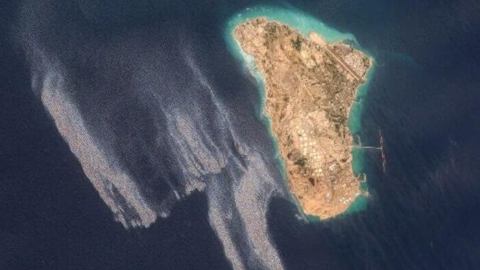
business44 days ago
Large Oil Slick Detected Off Iran's Kharg Island
Satellite images from May 6 to 8 show a slick covering about 45 square kilometers west of Kharg Island, Iran's primary oil export terminal. The cause remains unknown, with possibilities including a leak or other operational factors. Iranian officials condemned recent U.S. actions…
 indiatoday.intoday.in
world44 days ago
Suspected Oil Spill Detected Near Iran's Kharg Island Export Terminal
Satellite images have revealed a suspected oil spill in the waters near Iran's Kharg Island, a key crude oil export hub. The spill was identified in imagery reviewed on May 8, 2026. Iranian authorities have not issued a public statement on the incident.
 Wired
Wiredworld45 days ago
NASA Satellite Maps Mexico City Sinking at Up to 2cm Per Month
The NISAR satellite, a joint NASA and ISRO project, has produced detailed radar maps showing uneven subsidence across Mexico City, with some areas including the main airport sinking more than 2 centimeters monthly. The phenomenon, first documented in 1925, stems from groundwater…
world47 days ago
Open-Source Tool Shadowbroker Tracks 25,000 Ships, Spy Satellites on Unified Map
A new open-source tool called Shadowbroker has been released, enabling tracking of over 25,000 ships, carrier strike groups, spy satellites, and GPS jamming zones on a single map. It also includes more than 2,000 live CCTV feeds. The tool is available for free.
MA