Topic
satellite-imagery
31 stories related to this topic, newest first.
 middleeasteye.net
finance1 day ago
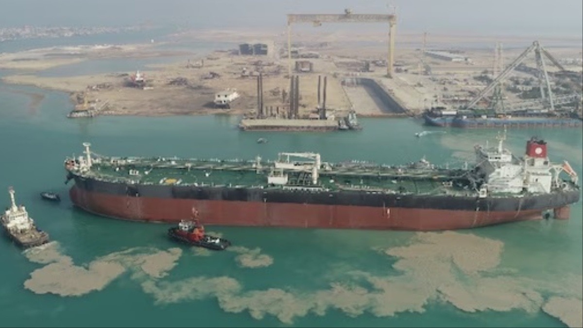
Satellite images show tankers loading at Iran's Kharg Island oil terminal
Recent satellite imagery captured multiple supertankers loading crude at Iran's main export facility. The images indicate resumed export activity at the terminal.
JA
 thehindu.com
world10 days ago
Satellite images show damage at 51 Iranian military sites and repairs at some missile bases since February
BBC Verify analysis of satellite imagery documents strikes on more than 50 Iranian bases, including IRGC headquarters, airfields and naval facilities, amid ongoing exchanges of fire despite a month-long ceasefire.
 bellingcat.com
world12 days ago
Satellite Images Show Possible Damage at Israeli Air Base
New satellite imagery indicates possible damage near a hangar at Israel's Ramat David Air Base. The extent of any impact remains unclear amid recent Iran-Israel exchanges.
JE
 thehindu.com
world15 days ago
Satellite Imagery Shows Fires at Russian Naval Arsenal Following Ukrainian Drone Strike
@Osinttechnical reported that Sentinel-2 imagery showed the facility engulfed in flames after a Ukrainian drone strike this morning, with burning ammunition bunkers igniting small wildfires.
OS
thehindu.comworld16 days ago
Commercial satellite images have improved Ukraine drone strike speed and precision
Images from commercial satellites operated by Colorado-based Vantor have increased the speed and precision of Ukraine's drone attacks over the past six months. The data show faster targeting cycles and higher strike accuracy against Russian positions.
 nbcnews.com
world17 days ago
Satellite Images Show Apparent Damage at U.S. Airbase in Kuwait
Satellite imagery indicates visible damage at a U.S. airbase in Kuwait following an Iranian attack. The images were shared online and analyzed by multiple observers.
ZE
 Newsweek
politics19 days ago
Satellite Images Show Unidentified Object at Scarborough Shoal Lagoon Entrance
Satellite imagery captured an unidentified reflective object less than 10 meters in diameter at the southern entrance to Scarborough Shoal's lagoon between May 26 and 28. Philippine officials are investigating the object's nature and origin while efforts to verify its status cont…
 rediff.com
world20 days ago
Satellite Images Show Damage at UAE Air Base After March Strikes
New satellite imagery shows damage to aircraft, radar systems, and facilities at Al-Dhafra Air Base following strikes in March. The base houses advanced U.S. and UAE defense equipment.
MA
 Substrate placeholder — needs review
world20 days ago
Iran Claims Strikes on US Military Sites in Middle East as Pentagon Reports Major Counterstrikes on Iran
Satellite images analysed by BBC Verify show damage to air defence systems, aircraft and radars at bases in Saudi Arabia, the UAE, Qatar, Kuwait, Iraq, Jordan, Bahrain and Oman.
 nbcnews.com
politics21 days ago
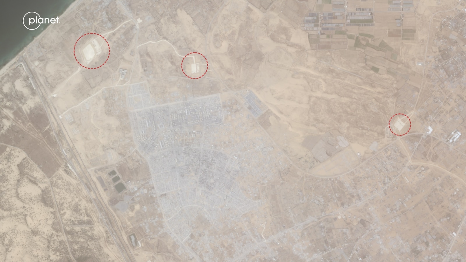
Satellite Images Show Israeli Military Positions in Areas of Khan Younis and Rafah Previously Used as Civilian Sites
Updated February 2026 imagery documents the transformation of cemeteries, housing projects, and universities into military sites across Gaza. Prime Minister Netanyahu directed forces to expand control to 70 percent of the territory.
 Defense News
world22 days ago
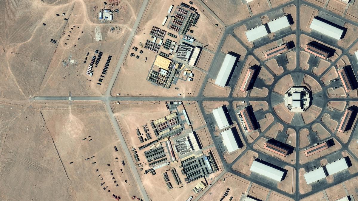
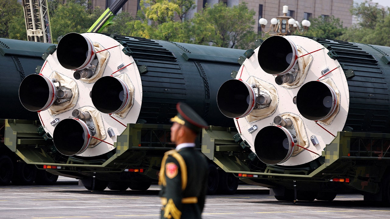
Satellite Images Reveal Octagon-Shaped Military Facilities Near China's Hami Nuclear Silo Fields
New satellite imagery reveals two octagon-shaped military sites southwest of China’s Hami nuclear silo fields, connected to more than 80 concrete pads by roads and conduits. The Pentagon estimates China is on track to field 1,000 nuclear warheads by 2030.
 thehindu.com
politics23 days ago
Satellite Images Show China Building Desert Launch Pads Near Nuclear Silos
New satellite imagery reviewed by Reuters reveals more than 80 launch pads and supporting facilities under construction near China's nuclear missile silos in Xinjiang. Analysts say the network appears designed to strengthen second-strike capability.
 theinertia.com
science25 days ago
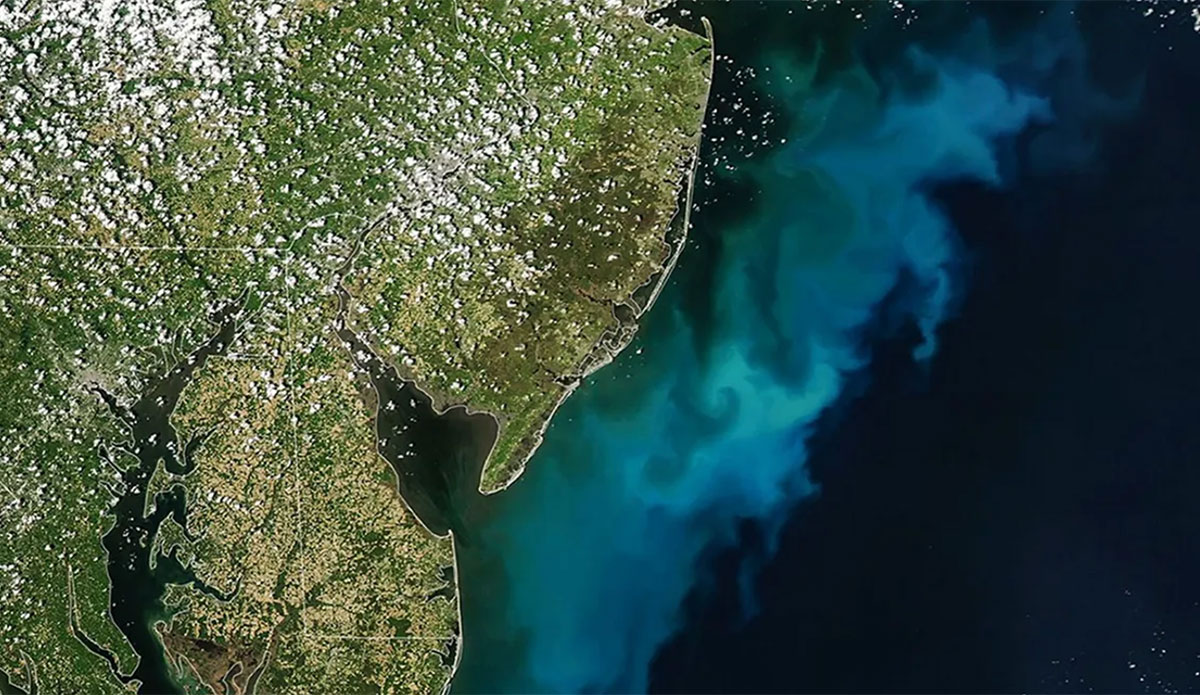
NASA Satellite Images Show Phytoplankton Bloom Off Mid-Atlantic Coast
Satellite data from NASA show a phytoplankton bloom producing turquoise water along the Jersey Shore and other Mid-Atlantic beaches. The bloom began in early April and remains visible in coastal zones from New Jersey to Virginia.
 abcnews.go.com
world27 days ago
Satellite Images Show Damage in Rafah's Al-Shabura Neighborhood
Before-and-after satellite imagery depicts changes to the Al-Shabura neighborhood in southern Gaza's Rafah area. The images document the extent of physical alteration in a previously built-up residential zone.
MA
 indianexpress.com
world28 days ago
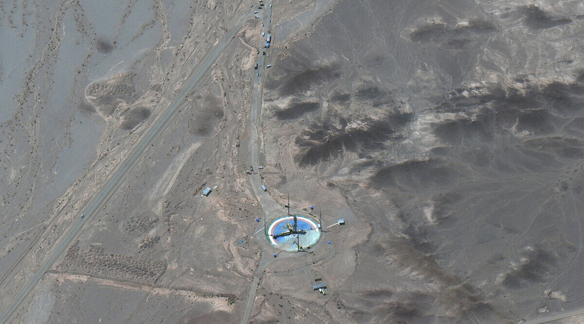
Satellite Images Show Two Iranian Missile Sites Operational After Reported Strikes
Satellite imagery dated May 24 shows the Larestan underground missile facility in Fars Province and the Abyek site are both active. The images indicate entrances previously reported closed have been reopened.
MA
 FDD
FDDworld31 days ago
Satellite Images Show Wall Construction Along Gaza Yellow Line
New satellite imagery indicates Israel is building a wall inside Gaza along the yellow line. Two sources reported the development on May 20, 2026.
AB
 rediff.com
world40 days ago
Satellite Imagery Shows 70km Oil Slick Off Iran’s Kharg Island
Satellite imagery has revealed a 70-kilometer oil slick spreading south from Kharg Island, which handles 90 percent of Iran’s crude exports. Iran denied any involvement in dumping and attributed the spill to the U.S. military campaign. Researchers reported that such spills have b…
MA
 foxnews.com
politics42 days ago
China Expands Nuclear Arsenal and Production Sites
Satellite images show China has doubled its nuclear capacity over the last decade after previously maintaining a minimal arsenal. The expansion includes new production sites for weapons. NPR reported the developments on May 10, 2026.
 thegatewaypundit.com
world42 days ago
Satellite Images Show Oil Slick Spreading From Iran’s Kharg Island
Satellite images indicate an oil slick has formed off Iran’s Kharg Island, a major crude export terminal, and is spreading across the Gulf. A professor told Al Jazeera that a spill in the area risks becoming an environmental and geopolitical issue. He called for rapid independent…
AJ
 Al Jazeera
finance43 days agoUpdated
Satellite Images Show Shrinking Oil Slick Near Iran’s Kharg Island
New satellite imagery shows a suspected oil slick spanning dozens of square kilometres near Iran’s main oil export hub in the Persian Gulf. Reports estimate tens of thousands of barrels may have leaked, though environmental observers say the slick is shrinking despite initial fea…
KO
AJ
 indiatoday.intoday.in
world43 days ago
Satellite Images Show Oil Tankers Burning Off Iranian Port of Jask
Satellite imagery released on May 10, 2026, shows multiple oil tankers struck and burning off the Iranian port of Jask. One image depicts an Iranian tanker with visible fire at its stern following what the source described as an American bomb strike. The extent of damage, casualt…
OS
 tass.com
finance46 days ago
Satellite Images Show Iran Loading Three Tankers at Kharg Island
Satellite imagery from May 6 captured three tankers being loaded simultaneously at Iran's Kharg Island terminal. The images come from the European Union's Copernicus Sentinel-2 program. The activity indicates continued oil exports from Iranian wells.
JA
thehindu.comworld46 days ago
Iran Fires Missiles at US Bases in Iraq and Syria
Imagery published by Iranian state-affiliated media and verified by The Washington Post reveals far more extensive damage to U.S. bases and assets than previously reported by the White House or Pentagon. The findings indicate Iran hit far more U.S. military assets than acknowledg…
GG
 usethebitcoin.com
finance50 days ago
US Sanctions Iran-Linked Oil Tanker
Satellite imagery from May 2 revealed Iran loading another oil tanker. The U.S. Treasury sanctioned one such tanker, leaving 217 others unsanctioned, including 37 very large crude carriers. One of those carriers is currently loaded with 2 million barrels of oil inside Iran.
JA
TA
thehindu.comworld56 days ago
Iran Uses Satellite Imagery for Targeted Strikes on U.S. and Allied Infrastructure
Iran carried out recent strikes that targeted specific U.S. and allied infrastructure node by node. Former CIA official Larry Johnson stated that Iranian planners used high-resolution satellite imagery to blind and ground targets. The strikes demonstrated a sophisticated level of…
MA
thehindu.comworld68 days ago
Satellite Imagery Confirms Damage to Structures at Camp Buehring in Kuwait After Strikes
Satellite imagery has confirmed damage at Camp Buehring in Kuwait following strikes attributed to Iran. Affected structures include two helicopter shelters, a warehouse, and a maintenance facility. The imagery shows multiple key structures were hit.
MA
Substrate placeholder — needs reviewfinance69 days ago
Satellite Imagery Shows Tanker Departing Kharg Island with AIS Spoofing
Satellite imagery has captured a tanker leaving Kharg Island in Iran while its Automatic Identification System signal indicated a departure from Saudi Arabia. This spoofing technique masks the vessel's true origin. The observation highlights ongoing monitoring of maritime activit…
TA
Substrate placeholder — needs reviewworld71 days ago
Planet Labs Restricts Satellite Imagery of Iran and Middle East Areas
Planet Labs announced it is indefinitely restricting satellite imagery coverage of Iran and parts of the Middle East. The company stated the decision follows pressure from the United States government. This action limits access to commercial satellite data for those regions.
Substrate placeholder — needs reviewai73 days ago
Nature Publishes Two Studies on Multiomics, Deep Learning, and Satellite Analysis of Human Activity
Nature has released two separate research papers. One employs multiomics and deep learning to analyze regulatory syntax in human development. The other uses satellite imagery to examine volatility in human night-time activity patterns.
NA
Substrate placeholder — needs reviewscience73 days ago
Satellite Imagery Shows Rising Volatility in Global Human Night-Time Activity
A study published in Nature analyzed satellite data from 2012 to 2022, revealing increased fluctuations in night-time light emissions worldwide. The research indicates that human activity patterns have become more variable over this period. Findings suggest potential links to soc…
NA
Substrate placeholder — needs reviewfinance77 days ago
Satellite Imagery Detects Sanctions-Compliant VLCC Supertanker Entering Gulf via Strait of Hormuz Without AIS
Satellite imagery analysis by TankerTrackers indicates that an empty very large crude carrier (VLCC) supertanker, compliant with sanctions, entered the Persian Gulf through the Strait of Hormuz on Thursday with its Automatic Identification System (AIS) transponder disabled. The v…
TA